What the Munsiyari Terrain Looks Like
Why Munsiyari Is the Gateway to the High Himalaya
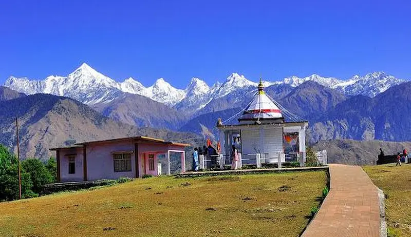
Munsiyari sits at approximately 2,200 metres on a natural balcony in the Kumaon Himalayas, directly facing the five summits of the Panchachuli massif (6,312–6,904 m). Unlike Garhwal trekking bases such as Sankri or Uttarkashi, Munsiyari belongs to the eastern Himalayan corridor of Uttarakhand — a region shaped by the ancient Johar Valley trade route that once connected Kumaon to Tibet through the Milam and Ralam passes.
The town retains a frontier character that most Himalayan destinations have long lost. There is no mall road, no resort strip, no queue at a viewpoint. What exists instead is a working mountain settlement where Johari Bhotiya families maintain traditions of wool trade, pastoral migration, and mountain guiding that predate colonial records. The Goriganga River carves through the valley below, fed by the Milam, Ralam, and Namik glaciers — the same glaciers that define the trekking routes radiating from this basecamp.
Munsiyari's elevation profile is fundamentally higher than Chakrata or even Sankri. Treks here begin above 2,200 metres and push towards 3,600–4,000 metres within days, entering glacial terrain that demands genuine physical preparedness. This is not weekend trekking. This is the high Himalaya — exposed, remote, and profoundly rewarding for those who come prepared.
Best Time to Trek in Munsiyari
Late spring (May–June): The premier trekking window. Snow recedes above 3,500 metres, high passes become navigable, and the Panchachuli range is visible with extraordinary clarity in the pre-monsoon light. Wildflowers blanket the alpine meadows between Munsiyari and the glacier basecamps. Daytime temperatures at town elevation reach 20–25°C, dropping sharply above 3,000 metres.
Post-monsoon (September–October): The second-best window. Kumaon receives heavy monsoon rainfall through August, but by mid-September the skies clear to reveal the sharpest mountain views of the year. Autumn colour transforms the birch and oak forests, and trail conditions stabilise. This is the quietest season — fewer groups, more solitude.
Winter (November–February): Munsiyari itself receives snowfall, and the road from Birthi Falls onward becomes treacherous or impassable. Higher trails are buried under deep snow. Only experienced winter mountaineers should consider this season, and only with fully self-supported expedition logistics. The town largely shuts down for tourism.
Monsoon (July–August): Not recommended for trekking. The Kumaon Himalaya receives some of the heaviest monsoon precipitation in Uttarakhand. Trails become dangerously slippery, river crossings swell, and landslides routinely block the road between Thal and Munsiyari. Leech activity is intense in forested sections below 3,000 metres.
Popular Treks from Munsiyari
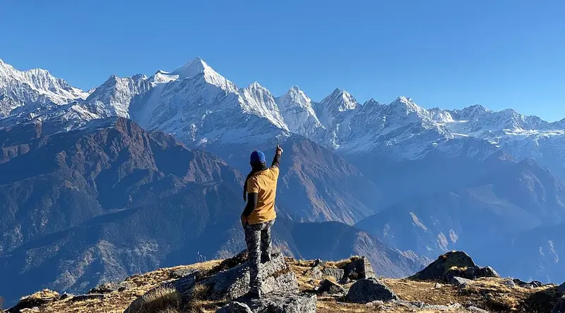
Khaliya Top Trek: The most accessible route from Munsiyari — a steady climb through dense rhododendron and oak forest to an alpine meadow at approximately 3,500 metres. The summit meadow offers an unbroken 180-degree panorama of the Panchachuli range, Nanda Devi East, and the Rajrambha peaks. This is a 2-day out-and-back trek suitable for fit beginners, and the closest Munsiyari comes to a "short trek" — though at this altitude, even short means demanding.
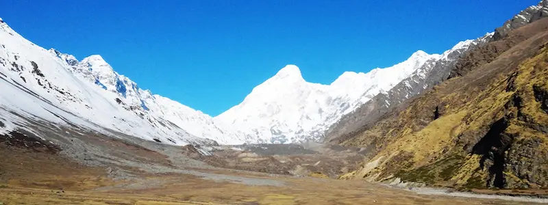
Milam Glacier Trek: A 7–9 day expedition following the Goriganga River to the snout of the Milam Glacier at approximately 3,450 metres. The route passes through the abandoned trading village of Milam and traces the historic Johar trade route to the Tibetan border. This trek requires Inner Line Permits (issued at the Munsiyari SDM office) and is restricted to Indian nationals for sections near the border. The terrain is glacial moraine, river crossings on improvised bridges, and exposed valley walking — a genuine expedition, not a guided nature walk.
Ralam Glacier Trek: A less-frequented alternative to Milam, the Ralam route follows the Ralam River to its glacial source at roughly 3,600 metres. The trail passes through pristine birch forests and moraine fields with virtually no other trekking groups. This is Munsiyari at its most remote — 6–8 days with no resupply points, no mobile coverage, and no shortcuts. Inner Line Permits are required.
Nanda Devi Base Camp (via Munsiyari approach): Advanced-level expedition trekking towards the eastern approaches of the Nanda Devi Sanctuary. This is not a standard commercial trek but a serious mountaineering approach requiring permits, experienced guides, and full expedition logistics. The route offers some of the most dramatic high-altitude scenery in the Indian Himalaya.
Terrain & Difficulty Profile
Munsiyari treks operate in a fundamentally different terrain band than Chakrata or Sankri. The difficulty floor here is higher, the exposure greater, and the safety margin thinner. Understanding the terrain zones is essential for preparation:
Subalpine forest (2,200–3,000 m): Dense oak, rhododendron, and birch forest with steep, rooty trails. These sections are sheltered from wind but demanding on the legs — consistent uphill gradient with few flat sections. Leeches are present during and after monsoon.
Alpine meadows and treeline (3,000–3,500 m): Above the forest canopy, the terrain opens to exposed grasslands and rocky ground. Weather changes rapidly at this altitude — clear mornings can turn to hail or whiteout within an hour. The Khaliya Top trek culminates in this zone.
Glacial moraine and river valleys (3,000–4,000 m): The Milam and Ralam glacier routes traverse loose rocky moraine, glacial rubble, and braided river beds. Footing is unstable. River crossings — over log bridges or by wading — are required at multiple points. Water levels fluctuate daily with glacial melt, making afternoon crossings significantly more dangerous than morning ones.
Who this terrain suits: Munsiyari treks are not beginner-friendly. The Khaliya Top trek is accessible to fit, determined first-timers, but the glacier treks require prior multi-day Himalayan experience, comfort with altitude above 3,000 metres, and the physical endurance for 6–8 consecutive trekking days. If you are planning your first Himalayan trek, start with Chakrata or Sankri and build your mountain fitness before attempting Munsiyari's glacier routes.
Need help choosing between Munsiyari treks?
Get a Free Recommendation →Expert advice · 2-minute response · No obligation
How to Reach Munsiyari
From Delhi: Take an overnight train or bus to Kathgodam (290 km, 7–8 hours by road, or 6 hours by Shatabdi Express). From Kathgodam, Munsiyari is a further 275 km — approximately 10 to 12 hours on mountain roads via Almora, Bageshwar, and Thal. This is not a casual drive. The road narrows progressively after Bageshwar, with hairpin switchbacks cut into steep valley walls. Allow a full day for the Kathgodam–Munsiyari leg.
From Kathgodam/Haldwani: Shared jeeps and state transport buses run daily to Munsiyari, departing early morning. The route passes through Almora (a useful overnight stop to break the journey) before climbing through Bageshwar and into the Goriganga valley. Road quality is acceptable to Thal; the final 90 km from Thal to Munsiyari is narrow, winding, and subject to landslide disruption during monsoon.
Remoteness factor: Munsiyari's access challenges are real and should be factored into trip planning. Unlike Chakrata (3 hours from Dehradun) or Sankri (10 hours from Dehradun), reaching Munsiyari requires a minimum two-day travel commitment from Delhi. This remoteness is also its greatest asset — it filters out casual traffic and preserves the authentic mountain character that defines the experience.
Permits: Standard treks like Khaliya Top require no permits. Glacier treks towards Milam, Ralam, or Nanda Devi approaches require Inner Line Permits, obtainable at the Munsiyari SDM (Sub-Divisional Magistrate) office. Processing takes 1–2 days. Carry passport-size photos and valid ID. Foreign nationals face additional restrictions on routes near the Indo-China border — check current regulations before planning.
Munsiyari vs Sankri vs Chakrata
All three are Uttarakhand trekking destinations, but they serve completely different audiences y and ambitions. Choosing between them is not about quality — it's about matching the destination to your experience level, available time, and what you want from the mountains.
Elevation range: Chakrata operates between 1,800–2,400 m (forested ridges, no altitude concern). Sankri pushes to 3,500–3,800 m (alpine meadows and snow summits). Munsiyari reaches 3,500–4,000+ m on glacier treks with genuine high-altitude exposure and glacial terrain that neither Chakrata nor Sankri approach.
Duration commitment: Chakrata is a weekend destination (2–3 days). Sankri requires 5–7 days including travel. Munsiyari demands 8–14 days for a glacier trek including travel — this is expedition-scale time commitment.
Terrain character: Chakrata offers sheltered forest trails and limestone caves on a gentle ridge. Sankri provides classic alpine trekking through meadows (bugyals) and snow slopes. Munsiyari delivers raw glacial valleys, moraine fields, river crossings, and exposed high-altitude terrain with minimal trail infrastructure.
Ideal trekker profile:
- Chakrata: First-timers, families, weekend warriors, trek-and-retreat combos
- Sankri: Intermediate trekkers seeking snow summits and alpine meadow camping
- Munsiyari: Experienced Himalayan trekkers ready for multi-day glacier expeditions and genuine remoteness
If you are building your trekking progression, the natural sequence is Chakrata → Sankri → Munsiyari — each step increases altitude, duration, remoteness, and reward.
Frequently Asked Questions
Is Munsiyari suitable for beginner trekkers? The Khaliya Top trek is accessible to fit beginners with determination and proper guidance. However, the glacier treks (Milam, Ralam) are not beginner-appropriate — they require prior Himalayan experience, comfort at altitude, and multi-day endurance. If this is your first mountain trek, consider starting at Chakrata.
Do I need permits for trekking in Munsiyari? Khaliya Top requires no permits. All glacier treks and routes approaching the Indo-China border require Inner Line Permits from the Munsiyari SDM office. Processing takes 1–2 days — plan accordingly and carry photo ID and passport-size photographs.
How long should I plan for a Munsiyari trip? For Khaliya Top: 4–5 days total (including travel). For Milam Glacier: 12–14 days. For Ralam Glacier: 10–12 days. Add buffer days for permit processing and weather contingencies. Munsiyari does not reward rushed itineraries.
Is there mobile coverage in Munsiyari? BSNL has intermittent coverage in Munsiyari town. Jio and Airtel are unreliable. Beyond the town — on any trek route — there is no mobile coverage whatsoever. Carry a fully charged power bank and inform family of your itinerary before departing.
Can I combine a trek with a retreat? Yes — our Munsiyari retreats are designed for visitors who want contemplative mountain time without the physical intensity of a glacier expedition. A Khaliya Top trek pairs well with a subsequent retreat for those wanting both adventure and stillness.
Why Munsiyari Is a Premier Trekking Destination
Munsiyari has become one of the most popular trekking bases in Uttarakhand because of its unique combination of accessibility, varied terrain, and transformative mountain experiences. Whether you are looking for your first Himalayan trek or a challenging multi-day expedition, Munsiyari offers routes suitable for all fitness levels and ambitions.
Talk to a Munsiyari Local Expert
Not sure which Munsiyari trek is right for you? Our local team can help you choose the best route based on your fitness, schedule, and previous experience.
Free consultation · No spam · Local team