Milam Glacier trek from Munsiyari through the Johar Valley, abandoned villages, and remote Kumaon terrain on a challenging 10-day route. Frequently listed among the Uttarakhand expedition treks.
Why Milam Glacier Trek (3,450m) is Popular
Milam Glacier Trek (3,450m) – The Old Indo-Tibet Trade Route is one of the most searched and recommended treks in Uttarakhand due to its unique landscape, accessibility, and the transformative experience it offers. This trek combines physical challenge with memorable views, making it a top choice for trekkers seeking both adventure and natural beauty in the Indian Himalayas.
Why Choose Milam Glacier Trek
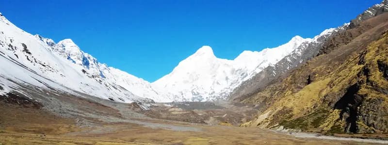
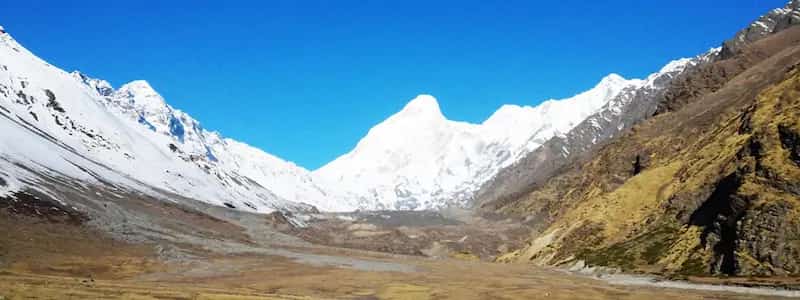
The Milam Glacier Trek is one of the longest and most culturally significant expeditions in the Indian Himalayas. Located in the remote Pithoragarh district of the Kumaon region, this 10-day, 118-kilometre journey begins from the spectacular town of Munsiyari. It follows the exact route of the ancient Indo-Tibetan trade corridor through the Johar Valley. The destination is the massive Milam Glacier—a 16-kilometre long river of ancient ice that serves as the treacherous source of the roaring Goriganga River.
While the glacier is the physical objective, the soul of this trek lies in its history. As you trek progressively deeper into the valley, you encounter the "ghost villages" of the Bhotiya people. Settlements like Bogudiar, Martoli, and Bilju were once fiercely wealthy trading hubs. Following the 1962 Indo-China war and the subsequent locking of the Tibetan borders, the economy collapsed, and the villages were largely abandoned overnight. Trekking through Martoli, with its hundreds of empty stone houses sitting completely silently against the massive backdrop of the Nanda Devi East and Trishuli peaks, is a profoundly haunting experience.
From a physical standpoint, the Milam Glacier trek is a masterclass in endurance. Interestingly, the altitude ceiling is relatively low (peaking at roughly 3,450 metres / 11,318 ft), completely neutralizing the severe risks of Acute Mountain Sickness (AMS). The true difficulty is simply the relentless distance. You must walk for 5 to 8 hours daily over undulating, sometimes heavily broken trails, crossing terrifyingly powerful rivers via basic suspension bridges, and scrambling over chaotic boulder moraines near the glacier snout. It is explicitly designed for seasoned trekkers looking to graduate from 5-day climbs to true, multi-week Himalayan survival.
Quick Facts
- Price: ₹18,500 - ₹24,000
- Duration: 10 Days / 9 Nights
- Difficulty: Challenging
- Max Altitude: 3,450 m (11,318 ft)
- Group Size: 6-10 Trekkers
How to Reach
- By Air: Pantnagar Airport is technically the closest, but New Delhi is far more reliable for connections.
- By Train: Kathgodam Railway Station is the main staging ground. The Ranikhet Express from Delhi runs overnight.
- By Road to Munsiyari: The drive from Kathgodam to Munsiyari is an exhausting 280+ km journey taking 12 hours. We organize shared jeeps picking up trekkers directly from Kathgodam at 6:30 AM on Day 1.
Permits & Safety
Permits: Milam Glacier lies directly on the highly sensitive Indo-Tibet (China) border. An Inner Line Permit (ILP) is strictly mandatory for all civilians. Our team handles the exhausting bureaucratic processing of this permit at the Munsiyari SDM office. You MUST provide a valid, original Government Photo ID (Aadhaar/Passport), three passport-sized photographs, and multiple photocopies. Foreign Nationals face severe restrictions and must apply for specialized clearance months in advance.
Roopkund Trek Cost
The typical cost for the Roopkund trek is ₹18,500 - ₹24,000. This includes most meals, camping, guides, permits, and support staff. See inclusions and exclusions below for details.
Why Milam Glacier is the ultimate Kumaon Expedition
The Milam Glacier expedition is not a trek; it is a profound journey into a lost world. Before the 1962 Indo-China war, the Johar Valley was a bustling, prosperous trade route connecting India to Tibet. Traders on yaks carried salt, borax, and wool across these very trails. When the borders sealed, the entire high-altitude civilization was abandoned. Today, trekking to Milam means walking for days through hauntingly beautiful, deserted stone villages like Martoli and Burfu, where intricately carved wooden doors still swing in the mountain wind.
Physically, it is an endurance masterpiece. You will walk 118 kilometres, tracing the violently roaring Goriganga River upstream until it violently emerges from the snout of the 16-kilometre-long Milam Glacier. This trek is isolated, raw, and completely devoid of the commercial crowds found in Garhwal. For trekkers seeking an authentic, punishing, and profoundly historic Himalayan expedition, there is nothing quite like Milam.
Moments you won’t forget
Haunted Ghost Villages
Camp amongst the spectral ruins of Martoli and Burfu. These once-rich trading hubs were abandoned decades ago, leaving behind beautiful stone houses frozen in time.
The Great Ice River
Stand before the Milam Glacier, a monumental 16-km long river of ancient blue ice and towering seracs, serving as the source of the mighty Goriganga river.
The Trishuli & Hardeol Massifs
As you journey deeper into the gorge, the imposing twin peaks of Trishuli (7,074m) and the "Demon Peak" Hardeol (7,151m) loom violently overhead, guarding the glacier.
A Test of Deep Endurance
Walking over 118 kilometres requires more than just fitness; it requires immense psychological resilience. The rhythm of the trail changes you entirely over 10 days.
- ✓Trekking 118 total kilometres deep into the restricted, highly isolated Kumaon borderlands.
- ✓Exploring the monumental snout of the Milam Glacier and the chaotic ice-falls that feed it.
- ✓Wandering through the chillingly beautiful ghost village of Martoli, abandoned since 1962.
- ✓Enjoying staggeringly close, aggressive views of Mount Hardeol (7,151m), Trishuli, and Nanda Devi East.
- ✓Hiking alongside the incredibly loud, violently fast Goriganga River through deep, narrow rock gorges.
A visual walk-through of the trail
Route Overview
Day 1: Drive from Kathgodam to Munsiyari (2,200 m) · 280 km · 11-12 Hours The expedition begins with a grueling but breathtaking 12-hour mountain drive starting from the Kathgodam plains. You will wind through the stunning Kumaon towns of Almora, Bageshwar, and Chaukori, crossing the majestic Birthi waterfall before finally ascending into the remote valley of Munsiyari. The Panchachuli peaks dominate the skyline. In the evening, you will meet your Expedition Leader, undergo a strict medical check, and ensure all Inner Line permits are secured for the sensitive border zones ahead.
Day 2: Trek from Munsiyari to Lilam (1,850 m) · 12 km · 5-6 Hours The walking begins. From Munsiyari, the trail rapidly plunges downhill toward the roaring Goriganga River. You hit the valley floor and begin following the river upstream through dense sub-tropical forests of bamboo and oak. The heat at this lower altitude can be surprising. The trail is well-paved but undulating. You cross your first suspension bridge over the river and arrive at the small, active settlement of Lilam, where you establish your first camp.
Day 3: Trek from Lilam to Bogudiar (2,450 m) · 13 km · 6 Hours Today, the gorge narrows violently. Leaving Lilam, you enter a deep, shadowy canyon carved entirely out of solid rock by the Goriganga. The trail has been blasted into the cliffside. The river churns aggressively just meters below you. You will climb steadily all day, occasionally passing spectacular, icy waterfalls crashing down across the path, requiring nimble footwork to stay dry. The canyon eventually opens up slightly as you arrive at Bogudiar, a strategic ITBP (Indo-Tibetan Border Police) checkpost where your permits are rigorously verified.
Day 4: Trek from Bogudiar to Martoli (3,200 m) · 14 km · 7 Hours One of the most dramatic days of the expedition. The trail continues ascending the gorge, transitioning from dense forest into stark, high-alpine shrubland. You will pass the settlement of Rilkot before a massive, arduous climb brings you out onto a high plateau. Suddenly, the ancient ghost village of Martoli appears on the horizon. Over a hundred stone houses sit completely abandoned against the terrifyingly sheer, icy walls of Nanda Devi East and Trishuli. You will camp in this hauntingly beautiful, desolate village for the night.
Day 5: Acclimatization and Exploration Day at Martoli A critical rest day to let your muscles recover from 40 kilometres of walking. You will spend the day exploring the ruined houses of Martoli, observing the intricate Bhotiya woodwork still surviving on the doors. You can hike up to the nearby Nanda Devi temple for stunning, 360-degree views of the peaks. Deep stretching and heavy hydration are mandatory today.
Day 6: Trek from Martoli to Milam Village / Glacier Basecamp (3,450 m) via Burfu · 14 km · 6 Hours You leave Martoli, crossing the river and entering the widest part of the Johar Valley. The landscape is entirely barren, alpine, and windswept. You hike past several more abandoned villages, including Burfu and Bilju, crossing a massive metal suspension bridge over the river. By early afternoon, you arrive at Milam Village, the very last settlement before the Tibetan border. Your basecamp is set up here, directly facing the massive lateral moraines of the glacier.
Day 7: Trek to Milam Glacier Snout and return to Basecamp · 6 km · 4 Hours The ultimate objective! Leaving your heavy gear at camp, you embark on a short, technical scramble over massive, unstable boulder fields—the dead moraine of the receding glacier. You will finally reach the snout of the Milam Glacier. The imposing, 16-kilometre long river of blue ice groans and cracks under its own weight, while the Goriganga river visibly explodes out from the ice cave at the bottom. You spend ample time absorbing the magnitude of the icefall and the guarding peaks of Hardeol before returning to basecamp.
Day 8: Trek from Milam to Bogudiar (2,450 m) · 24 km · 9-10 Hours The great retracing begins. With gravity on your side and lungs fully functioning at lower altitudes, you will conquer an incredibly massive distance today. You hike rapidly past Burfu, cross the river, breeze past the ruins of Martoli, and plunge back into the deep gorge, arriving exhausted but triumphant at the Bogudiar ITBP camp by late afternoon.
Day 9: Trek from Bogudiar to Munsiyari via Lilam · 25 km · 9-10 Hours The final, grueling push. You continue the long descent through the rock gorge to Lilam. The heat of the sub-tropical forest returns. The true mental test comes at the very end: the incredibly steep, demanding uphill climb from the river basin all the way back up to Munsiyari town. Hitting the tarmac road feels surreal. You return to the guesthouse, shedding your boots for a hot shower and an immense celebratory dinner.
Day 10: Drive from Munsiyari to Kathgodam · 280 km · 11 Hours You depart the high Kumaon mountains early in the morning, executing the long 11-hour drive back to the plains. You are dropped at Kathgodam railway station by dusk, carrying the weight of having walked 118 kilometres through the heart of the Himalayas. Do not book travel before 9:00 PM.
Upcoming Milam Glacier Trek (3,450m) – The Old Indo-Tibet Trade Route Departures
See upcoming milam glacier trek (3,450m) – the old indo-tibet trade route departures for all available dates.
| Date | Duration | Price | Seats | Action |
|---|---|---|---|---|
| 15 Mar 2026 | 4D/3N | ₹9,500 | 6 left | |
| 22 Mar 2026 | 4D/3N | ₹9,500 | 8 left | |
| 05 Apr 2026 | 4D/3N | ₹10,200 | 10 left |
Small group size (max 12 trekkers). Seats fill quickly during winter departures.
Overall: Challenging
Four independent axes. Use this to compare honestly against other Himalayan routes you’ve done.
- Physical Demandcardio + stamina
- Technical Skillrope / exposure
- Altitude ChallengeAMS risk
- Weather Exposurecold / wind / snow
Difficulty & Preparation
This trek is rated Challenging. Maximum elevation reaches 3,450 m (11,318 ft). Total route distance is approximately 118 km. The trek duration is 10 Days / 9 Nights from Kathgodam.
Best seasons: May, June, September, October. Plan your trip around these months for the safest conditions and best visibility.
This is a demanding route. Prior multi-day Himalayan trekking experience is recommended. Ensure you have adequate cardiovascular fitness, are comfortable with sustained daily walking over rough terrain, and have experience at altitudes above 3,000 metres. Consult a physician before committing if you have any altitude-related health concerns.
Why trekkers trust us for Milam Glacier Trek (3,450m) – The Old Indo-Tibet Trade Route
"The Milam Glacier Trek (3,450m) – The Old Indo-Tibet Trade Route experience was flawless. From the quality of the microspikes provided to the deep knowledge of our guide, I never felt unsafe even when the snow was knee-deep. The food at 10,000 feet was unbelievably good!"
NIM-Certified Leaders
Every trek leader holds an Advanced Mountaineering qualification and Wilderness First Responder certification.
Satellite Connectivity
Connected via Garmin InReach/sat-phone beyond the tree line for immediate emergency response.
Oxygen & Oximeters
Mandatory twice-daily oxygen saturation checks. Emergency oxygen cylinders carried on every batch.
Ready for the mountains?
Limited upcoming batches available for the Milam Glacier Trek (3,450m) – The Old Indo-Tibet Trade Route. Small groups of 12 max. Secure your spot before dates sell out.
Book Your Milam Glacier Trek (3,450m) – The Old Indo-Tibet Trade Route NowFree cancellation up to 7 days before departure.
Challenging · May–October
Best Time to Trek
The recommended months are May, June, September, October. These windows offer the most stable weather, safest trail conditions, and best mountain visibility.
Pre-monsoon (May–June): Clear skies, warming temperatures, and wildflower meadows at higher elevations. Snow may persist above 3,500 metres in early May, adding alpine character. This is typically the busiest trekking window.
Post-monsoon (September–October): After the monsoon rains withdraw, visibility sharpens dramatically. Autumn brings cooler temperatures, golden light, and far fewer trekkers on the trail. An excellent season for photography and solitude.
Month-by-Month Conditions
May: Pre-monsoon spring. The lower forests are relatively hot and humid during the day. The trail is heavily active as shepherds move their flocks to higher pastures. The upper Johar valley is blooming, though patches of hard snow may still survive near the actual glacier snout. Highly popular month.
June: Late spring. The days are long and warm. However, by mid-June, the pre-monsoon showers begin. The Goriganga river swells massively and becomes terrifyingly violent. Waterfalls crash onto the trail, requiring waterproof gear. If you trek in June, you must book the very first week to avoid the heavy rains.
September: Post-monsoon restart. The monsoon has triggered landslides, so the trail is often freshly repaired or slightly treacherous in spots. However, the washed-out atmosphere provides completely unparalleled, razor-sharp views of Hardeol and Trishuli. The valley is extremely lush and green.
October: Peak autumn. The absolute best month for serious trekkers. The air turns deeply dry and crisp. The temperatures drop sharply, frequently hitting freezing (0°C) at Martoli and Milam at night. The visual clarity of the glacial ice and the massive peaks above is absolutely flawless.
Safety & Precautions
The Milam Glacier expedition benefits heavily from a "reverse altitude profile" compared to standard treks. Maxing out at only 3,450 metres, the risk of severe Acute Mountain Sickness (AMS), HAPE, or HACE is impressively low. Your body has 6 days to acclimatize before reaching the highest point. However, the expedition is fraught with mechanical risks. The trail through the Goriganga gorge is often blasted out of sheer cliffs, requiring absolute focus to avoid fatal falls. During monsoon or post-monsoon, the trail is notoriously prone to landslides and flash-flooding from glacial melt. Our expedition leaders are trained Wilderness First Responders. We adhere strictly to ITBP (Border Police) warnings; if the paramilitary forces advise halting due to weather or trail collapse, the expedition halts immediately without negotiation.
Permits & Documentation
Milam Glacier lies directly on the highly sensitive Indo-Tibet (China) border. An Inner Line Permit (ILP) is strictly mandatory for all civilians. Our team handles the exhausting bureaucratic processing of this permit at the Munsiyari SDM office. You MUST provide a valid, original Government Photo ID (Aadhaar/Passport), three passport-sized photographs, and multiple photocopies. Foreign Nationals face severe restrictions and must apply for specialized clearance months in advance.
Who Should Reconsider
Milam Glacier is an endurance monster. If you have not completed a multi-day Himalayan trek previously, you should not attempt this. The sheer mental toll of walking 15 to 25 kilometres a day on Days 8 and 9 breaks many beginners. Anyone with chronic knee problems, ruptured ligaments, or cardiovascular issues must avoid this route entirely. You must have the stamina to continuously walk for 8 hours with a backpack, day after day.
Getting There & Local Info
Munsiyari is a reasonably well-stocked town, but high-end specialized trekking gear is hard to rent here compared to hubs like Sankri. You must buy or rent all essential gear (boots, thermal jackets, ponchos) before arriving. Munsiyari has ATMs (SBI), but they frequently run dry; you absolutely must withdraw all cash for tips, offloading, and snacks in Kathgodam. Communication is archaic. BSNL and Jio work in Munsiyari, but the moment you descend to Lilam on Day 2, you are plunged into an absolute digital blackout. There is no mobile network, internet, or electricity for the next 8 days. You must prepare your family for total radio silence. In an absolute emergency, our guides can use the satellite phones at the ITBP checkposts.
Included
- ✓Accommodation in standard guesthouses at Munsiyari and specialized four-season expedition tents during the trek.
- ✓All calorie-dense, highly nutritious vegetarian meals from dinner on Day 1 to Breakfast on Day 10.
- ✓Expert Expedition Leader, local Johari guides, cooks, and a full mule-train support team.
- ✓Comprehensive safety equipment including extensive medical kits, pulse oximeters, and emergency satellite comms.
- ✓Complete processing and payment of the strictly controlled Inner Line Permits for the restricted border zone.
Not Included
- —Transport from Kathgodam to Munsiyari and back (arranged on an additional cost-sharing basis).
- —Offloading of heavy personal rucksacks onto the mules (available at an extra, mandatory daily charge).
- —Personal expedition trekking gear like high-ankle waterproof boots, down jackets, and polarized sunglasses.
- —Any meals consumed during the highway transit over the 12-hour drives.
- —Mandatory trek insurance and emergency medical evacuation/helicopter rescue costs.
Frequently Asked Questions
Is Milam Glacier difficult because of altitude?
No. The altitude peaks at only 3,450m, which is lower than most beginner treks like Kedarkantha. The difficulty comes entirely from the sheer distance. Walking 118 kilometres over incredibly rocky, undulating, and sometimes unstable terrain requires immense muscular and cardiovascular endurance.
Can I do this if I have never trekked before?
We strongly advise against it. The sheer psychological pressure of being 5 days deep into a remote gorge with no roads, electricity, or internet breaks unprepared beginners. Start with a 5-day trek like Har Ki Dun before attempting this 10-day expedition.
Will we go exactly onto the glacier surface?
You will trek right up to the "snout" of the glacier—the violent ice cave where the river erupts from. Unless you have specialized ice-climbing equipment and permissions, walking directly onto the heavily crevassed main glacier body is highly dangerous and technically restricted.
Is the Inner Line Permit guaranteed?
For Indian nationals, the permit is almost always granted unless there is a severe military or weather emergency at the border. For foreign nationals, the regulations are incredibly strict and require applying months in advance; independent travel is often denied.
Can I charge my camera batteries?
There is zero electricity past Lilam. You must bring massive power banks or portable solar chargers capable of sustaining your electronics for 8 solid days. Keeping batteries warm inside your sleeping bag preserves their charge.
Looking for another challenging expedition trek? Consider the Roopkund Trek.
Explore more treks around Munsiyari or discover wellness retreats in Munsiyari.
Trekking in Munsiyari
Munsiyari is one of the most popular trekking regions in Uttarakhand, offering world-class Himalayan experiences. The region provides diverse routes including Milam Glacier Trek (3,450m) – The Old Indo-Tibet Trade Route and other renowned peak treks, snow treks, and valley expeditions. Whether you\\'re a beginner or an experienced trekker, Munsiyari has routes suitable for all levels of experience and fitness.
Milam Glacier Trek (3,450m) – The Old Indo-Tibet Trade Route — Complete Trek Guide
This comprehensive guide to Milam Glacier Trek (3,450m) – The Old Indo-Tibet Trade Route covers everything you need to know: trek cost, detailed itinerary, difficulty assessment, best time to visit, complete packing list, and insider tips. Learn about the altitude profile, permits required, how to reach the trailhead, acclimatization strategies, and what to expect on the trail. Whether you\\'re researching, planning, or preparing for Milam Glacier Trek (3,450m) – The Old Indo-Tibet Trade Route, this guide provides all the essential information and local insights to help you prepare for a successful Himalayan trekking experience.
Explore All Treks in Munsiyari
Munsiyari offers diverse trekking experiences with multiple routes suiting all fitness levels. Discover other peaks, valley treks, and scenic routes in the Munsiyari region for your next Himalayan adventure.
View All Treks in Munsiyari →