Roopkund vs Pangarchulla: Which Trek Is Right?
If you have completed moderate treks like the Brahmatal or Kuari Pass routes and are ready to step into challenging territory, the Garhwal trekking region offer two outstanding options: the Roopkund mystery lake expedition and the Pangarchulla Peak summit climb.
Both are rated challenging, both exceed 4,500 metres, and both demand prior high-altitude experience. But they test different skills, occur in different seasons, and deliver fundamentally different types of mountain achievement. This comparison helps you decide which challenge matches your experience and ambition. For the full range of routes from easy to expedition-grade, see our Uttarakhand trekking guide.
Roopkund vs Pangarchulla at a Glance
| Roopkund | Pangarchulla | |
|---|---|---|
| Base Town | Lohajung (2,350 m) | Joshimath (1,875 m) |
| Max Altitude | 4,800 m | 4,590 m |
| Distance | 53 km | 32 km |
| Duration | 7 days | 6 days |
| Difficulty | Challenging | Challenging |
| Best Season | May–Jun, Sep–Oct | Mar–May |
| Type | Expedition (lake destination) | Summit climb (peak) |
| Special Gear | Standard high-altitude kit | Crampons, gaiters required |
The Experience: Expedition vs Summit
Roopkund — The Mystery Lake Expedition
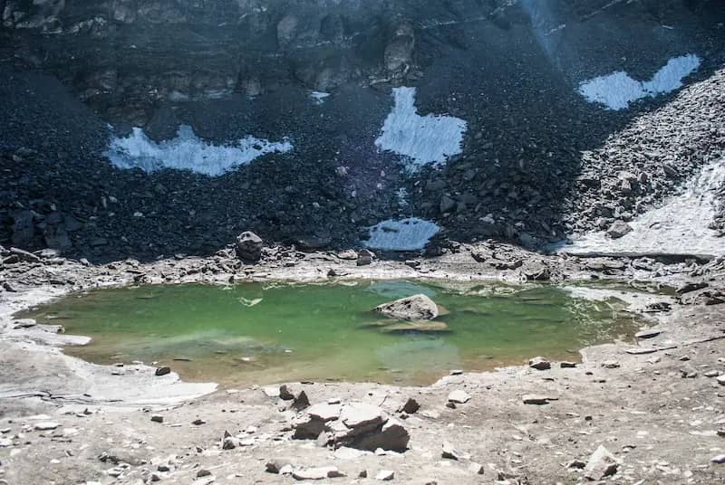
Roopkund is a journey trek. The destination — the glacial lake at 4,800 metres with its mysterious ancient skeletal remains — is the goal, but the route itself is rich in terrain transitions. You cross Bedni Bugyal (one of India's largest alpine meadows), ascend through exposed high-altitude moraine, and navigate terrain that changes character every day.
The challenge is cumulative: day after day above 3,500 metres. Roopkund tests endurance, altitude tolerance, and the ability to maintain morale across a week-long expedition in remote terrain. The final approach to the lake is steep and exposed but not technical.
Pangarchulla — The Summit Climb
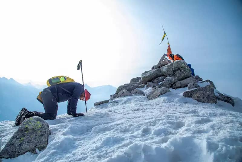
Pangarchulla is a peak trek. The first three days follow the scenic but non-technical Kuari Pass approach through forests and meadows. Then it diverges. Day five is summit day: a 3 AM alpine start from Khullara camp, a 700-metre climb through steep snow and scree, and arrival on a narrow peak with 360° views of the Nanda Devi Sanctuary.
The challenge is concentrated. You use crampons. You carry a headlamp. You push through physical limits. The reward — standing on a true summit — is a fundamentally different feeling from reaching a lake or a pass.
Fitness & Preparation Requirements
For Roopkund — Build Stamina
6–8 weeks of structured preparation. Daily cardio (running, cycling, or swimming) for cardiovascular base. Weekend hill hikes with a 10–12 kg pack for trail-specific conditioning. Core strength work for stability on uneven terrain.
The seven-day duration means your body must sustain effort across multiple consecutive days at altitude — stamina matters more than peak power.
For Pangarchulla — Build Power
6–8 weeks of preparation with emphasis on explosive climbing power. Stairmaster sessions, hill repeats, and loaded pack training for the summit day. Single-day fitness matters more than multi-day stamina — you need to climb 700 metres in 4–5 hours at altitude after a 3 AM start.
If you can power-hike 1,000 m elevation gain in under 3 hours at sea level with a pack, you are ready.
Altitude & Safety Considerations
Both treks operate well above 4,000 metres where Acute Mountain Sickness (AMS) risk is real:
Roopkund (4,800 m) — Gradual but High
The highest point in this comparison. You spend 2–3 days above 4,000 metres, which gives AMS more opportunity to develop. The altitude gain is gradual across the seven-day itinerary, which helps — but the final push to the lake at 4,800 m is the critical zone.
Guided operators carry pulse oximeters and follow descent protocols if symptoms appear.
Pangarchulla (4,590 m) — Rapid Single-Day Gain
Lower maximum altitude, but the summit push involves rapid altitude gain on a single day (Khullara camp at ~3,870 m to summit at 4,590 m). The acclimatisation profile depends heavily on the rest day at Khullara.
The combination of altitude, cold, and extreme exertion on summit day creates a unique physiological stress.
Season & Weather
Pre-monsoon (May–June) offers warmer conditions but more afternoon cloud. Post-monsoon (September–October) delivers sharper visibility and fewer trekkers. The monsoon gap (July–August) makes Roopkund entirely unavailable for a quarter of the year.
March and early April offer consolidated snow for the summit — the best conditions for crampon grip. Late April and May are warmer but the snow line rises, potentially exposing loose scree on the summit approach. The trek is not viable in monsoon, post-monsoon, or winter.
May is the only month where both are available. If you have a fixed May window and are deciding between them, the choice reduces to: do you want a week-long expedition to a mystery lake, or a summit climb with a concentrated challenge?
Who Should Choose Which
Choose Roopkund if:
- You want an extended expedition experience (7 days on trail)
- You are drawn to iconic destinations (the mystery lake)
- Your fitness favours sustained endurance over explosive power
- You prefer pre-monsoon or post-monsoon seasons
- You have completed at least one trek above 4,000 m
Choose Pangarchulla if:
- You want a true summit experience (standing on a peak)
- You thrive on concentrated, high-intensity challenges
- You are comfortable with crampons, alpine starts, and steep snow
- You prefer a spring trekking window (March–May)
- You have completed Kuari Pass or equivalent and want the next step
The Garhwal Progression
Both Roopkund and Pangarchulla sit at the top of the Garhwal difficulty spectrum. The natural progression for most trekkers through the region looks like this:
You do not need to follow this order rigidly, but each trek builds skills and altitude confidence that the next one demands. See our Garhwal Himalayas trekking guide for the full picture.
Frequently Asked Questions
Which is harder — Roopkund or Pangarchulla?
Both are rated challenging, but they are hard in different ways. Roopkund is longer (53 km, 7 days) with sustained altitude above 4,000 m across multiple days. Pangarchulla is shorter (32 km, 6 days) but the summit push involves a steep 700 m climb on a single day with an alpine start at 3 AM. Roopkund tests endurance and altitude tolerance; Pangarchulla tests single-day climbing power and cold-weather stamina. Most experienced trekkers consider the Pangarchulla summit day to be the more technically demanding single effort.
Can I do both treks in one trip?
Not practically. Roopkund starts from Lohajung (pre/post-monsoon) and Pangarchulla starts from Joshimath (spring only). The base towns are 6+ hours apart by road and the seasonal windows overlap only in May. Most trekkers do them as separate trips, typically in different years as progression milestones.
Which trek needs more prior experience?
Both require prior high-altitude trekking experience above 4,000 m. Pangarchulla additionally requires comfort with early alpine starts, steep snow climbing, and use of crampons. If you have done one challenging Himalayan trek (Kedarkantha in winter, or a similar 3,800+ m route), Roopkund is the logical next step. If you have done Roopkund or equivalent, Pangarchulla is the summit-grade progression.
What is the best season for each?
Roopkund: May–June (pre-monsoon) or September–October (post-monsoon). Pangarchulla: March–May only, when consolidated snow supports the summit approach. There is no autumn Pangarchulla season — early snow makes the summit unstable.
Which has better views from the top?
Pangarchulla offers a full 360° summit panorama including Nanda Devi, Nanda Ghunti, Dronagiri, and the inner Nanda Devi Sanctuary. Roopkund's view is dominated by the Trishul massif looming directly above the lake, with Nanda Ghunti to the east. The Pangarchulla summit is the more comprehensive viewpoint; Roopkund is the more dramatic single-image destination (the skeleton lake at 4,800 m).
Do I need a permit for Roopkund in 2025–2026?
Yes. Roopkund falls within the Nanda Devi Biosphere Reserve, and trekking requires a forest department permit obtained at the Lohajung check post. As of 2025, individual trekkers must register with an authorised guide or trekking operator — solo unsupported trekking is not permitted on this route. Permit fees are approximately ₹150–600 per person (Indian nationals) depending on the issuing authority. International trekkers pay higher fees. Your trekking operator typically handles permit logistics. Always confirm current permit status before departure, as regulations can change seasonally.
How difficult is the Pangarchulla summit day?
The Pangarchulla summit day is the single most demanding day on any standard Garhwal trek. You leave Khullara camp at 3 AM, climb 720 metres of elevation over 4–5 hours through steep consolidated snow and loose scree, reach the 4,590 m summit by mid-morning, and descend the same day. Crampons are mandatory for the final snow slope. The difficulty comes from the combination of altitude (above 4,000 m throughout), steep gradient (sustained 30–40° slopes near the summit), early alpine start in darkness and sub-zero temperatures, and the need to complete the round trip before afternoon weather deteriorates. Prior experience above 4,000 m is essential.